I have often complained about the lack on interesting roads out of Reno for any direction except West. If you are heading to California, there are any number of great routes which offer interesting and varied scenery as well as some history along the way. Otherwise you are doomed to a pretty boring ride though mostly unchanging desert landscapes that you would be hard pressed to distinguish between. But enough complaining already. I mostly criticize negative thinking and often chastise Mrs Hansford for her lack of a more positive outlook. My hope is that she will find some activity in retirement that she can become passionate about pursuing but so far no luck.
I did think at one point that I might be over critical in this respect so I decided that I would keep a daily dairy of events and note whenever she made a comment that I could construe as positive. I started this exercise at the beginning of summer on May first but so far have not had the occasion to make any entries. She did say toward the middle of September that, "I hope our granddaughter's new contact lens worked out for her". I think that was as positive as I got.
So no more whining.
I have been looking forward to taking a trip up to visit with my old friends from Alaska days, Donn and Karen Wonnell at their home just outside Sun Valley, Idaho. I had not seen them for a couple of years since I stopped by on my way up to Canada in 2012. I will be interested in learning how they and their families are doing. I am also hoping to enjoy the ride as well but have some doubts about seeing anything new or diverting since I have already covered all of the route choices several times before.
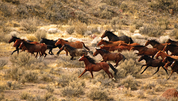
However, a couple of new areas are possibilities. One is the eastern side of my own County in Nevada, Washoe. Almost all the population of the county in in the extreme southern part around Reno and Sparks and is transited by the extremely busy Interstate 80 highway. The norther part of the county is almost devoid of people with only the very small town of Gerlach (population in 2010, 210) as the only settlement. The rest of the area is occupied by ranchers, Native Americans and wild horses.
On a ride in July of 2012 which I did not blog, I took the pavement from Reno up to Gerlach where the gravel begins just north of town and continues all the way to the border with Oregon. In fact there is only one paved road in the 80% of the county outside the Reno/Sparks area and that only transits the northeast corner from southern Oregon into neighboring Humbolt County, Nevada. On that occasion I stayed on the western side before crossing over to the small boarder hamlet of Denio in Humbolt County. Once in Oregon, I had hoped to spend the night in the very small village of Frenchglen which had the only overnight accommodations for many miles in any direction. This southeastern part of Oregon is nearly as unpopulated as Nevada. I got lost and ended up spending several more hours on very rural gravel roads before finally finding a place for the night in Jordan Valley, OR right on the border with Idaho.
There is one exception to this population description. For a little less than one week per year, northern Washoe county is the location of the 4th or 5th largest town in Nevada.
2012 Ride to Canada Day One
By the time I arrived at Jordan Valley it was getting very dart and I had covered over 400 miles, nearly half of them unimproved gravel. I was lucky to find space in a very average, two story cinderblock motel which was the first overnight accommodations I had seen the entire day. A poor mattress in a seedy room was seldom more appreciated.
In planning this year's ride, I thought about taking a different route north from Gerlach which covers the eastern part of Washoe County. However after a lot of looking at the maps and Internet posts, I decided that the county I would see was unlikely to be much, if any, different from the ride a couple of years before. I also thought about taking Interstate 80 east to Wells, Nevada and then north through Twin Falls, Idaho and then on to Ketchum. Since I had covered all of I80 just a month before when coming home from the 2014 Canada trip, I was not anxious to retrace that route in the opposite direction. All in all, it seemed the best choice was to just bit the bullet and take I80 east to Winnemecca, NV and then US95 north to Oregon and on to Boise, Idaho. But taking into account the limited options for overnight accommodations, I did something which I normally try to avoid when on a ride. That is making advance reservations. Normally, I like to just take my chances on finding an available room in whatever location I find myself at the end of the day. I like the freedom of not having to follow an itinerary and it also allow me to explore anything of interest along the way without worry about missing a reservation. It is also a safety issue with me. I believe that many bike accidents happen when the rider is tired or distracted. Rather than always having to make a certain destination every day, taking pot luck of available hotels, allows me to quit early if I am finding myself getting tired or distracted. By and large, maintaining this freedom has worked out for me but there have been a handful of times when I have found myself in a location without a single available room. Sometimes that is a real problem and means that I will have to try the next town which can be quite a distance away, particularly in the American and Canadian West where motels can be pretty widely spaced.
In this case, if I made it to Boise the first day, I was sure there would be no problem since that was a town of some half a million with plenty of accommodations. But that would mean a ride of about 450 miles which was more that I really like to do in a day and to do that much on the first day means that you are going to start the trip tired. From earlier experience however I knew that not making it that far meant that the options were very limited, in fact, limited to one. that was to stay the night in Jordan Valley again and offered only two hotels with very limited rooms. In 2012 I had first tried a small Restaurant & Inn allied the Old Basque Inn. They had no rooms available that night but I did have a reasonable evening meal there. I called the Inn and made a reservation. So the first day's schedule was set. Maybe not the most interesting or exciting ride but one that should be uneventful. And sometimes that's good.
It was not surprising to me that both Jordan Valley spots carried the Basque name.
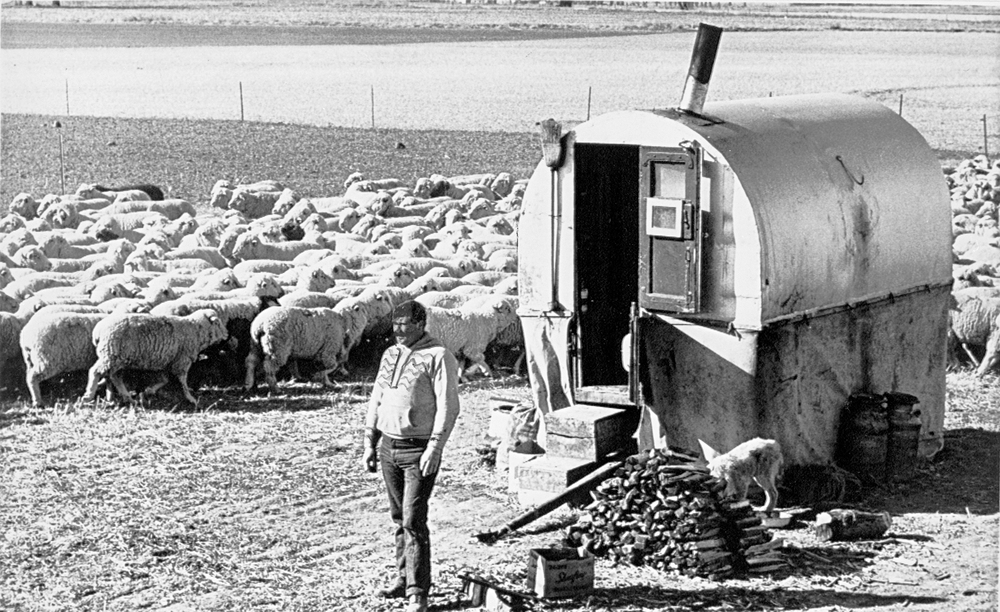
A Basque shepard and his wagon in Eastern Oregon
Unlike much of the rest of the American West where lush virgin grassland could support large scale cattle ranching, the very dry high desert plains of Nevada and southern Oregon could not. Instead sheep were brought into the region in fairly large numbers. With the introduction of sheep came the need to shepards and there are few better at tending remote flocks than the Basques. As a result, many were brought over from their native homeland in southern France and northern Spain to the lonely reaches of this part of America. They brought their unique culture and food with them which still echoes throughout our region today.
I suspect that some of you who are not from this part of North America are wondering a bit about my earlier reference to Northern Washoe County hosting the 4th or 5th largest city in Nevada for one week per year. It is the Burning Man Festival held each year in the harsh and unforgiving Black Rock Desert National Conservation Area just beyond the town of Gerlach. For those of you who know of the event, no explanation is necessary, for those of you who do not, no explanation is possible, at least not here and not now.
Black Rock City is composed of campsites around a central "Burning Man" sculpture
Suffice it to say that every year more than 50,000 people of all ages and social status from over 50 counties around the world build a camp on the bone dry, talcum power-like dust of the desert for a
week of celebration of the extremes of human creativity and behavior. The festival lasts for one week and ends on the first Monday in September. On Saturday night, a newly created structure made in the form of a man is burned to the ground. Click on the map link above and see the exact location of Burning Man City.
The Black Rock Desert is controlled by the Federal Bureau of Land Management. While the BLM is widely disposed in the west for what are often characterized as restrictive land-use practices, in this case, they require the organizers of Burning Man to post significant bonds to guarantee that the desert will be returned to its original pristine condition when all the "burners" leave. This tradition of leaving no mark on the land has become one of the hallmarks of the festival. No permanent structures are permitted and all debris must be removed with the site completely restored.
Reno to Jordan Valley, Oregon. As expected, the ride up US95 to Oregon was uneventful and uninspiring. Except for a short section north from Winnemucca where a bit of water allows for a bit of vegetation and some people to exist there is just not much to see. The route is all highway with the first half Interstate and the last excellent two lane.
2014 Visit to Wonnell's Day One
There is not much to see until you get close to Jordan Valley and even then the scenery is not dramatic but sure beats mile after mile of desert sagebrush.
On the road just outside of Jordan Valley you can see the low mountains in the Eastern distance
At least there is enough water in the JV area that grass will grow. A real change from the actual desert of Nevada. The group of rocky hills (right) which rise above JV are just west of town and a part of some interesting but barren and forbidding landscapes.
The Old Basque Inn
Resturant and Rooms
I had not fully committed to the Oregon route until I arrived at Winnemucca. Knowing how sparsely populated the region was, I called ahead for a reservation at the Old Basque Inn which had no vacancies the last time I rode through town a couple of years before. The Inn featured a resturant downstairs and a few guest rooms on the second floor.
I was surprised to see this old-style payphone hanging on the wall in the upstairs hall. No phones in the guest rooms and the washroom was down the hall as well. I was a bit shocked to learn that even without telephones they did have a wireless Internet connection. One with decent speed as well. As it turned out, I needn't have worried about sharing the bathroom. On this Sunday night I was the only guest. No phone, no TV or running water but the small single bed was clean and comfortable. The next time I am JV, I will be staying at the Old Basque Inn. The cost included a full menu, cooked-to-order breakfast which was delicious. Perhaps the best value accommodations I have had in quite a long while.
My plan for the day was pretty well fixed; I just wanted to get to the Wonnell's in time for dinner. It should not have been a challenge since I had covered this route before and the total trip was only a bit over 225 miles on good paved roads. After having already completed one fairly uneventful and unspectacular day, I decided to do some exploring. As I have mentioned before most of south east Idaho is pretty much empty. However searching the area on the Internet at breakfast, I had come across an old mostly abandoned mining town named Silver City. From the Google Maps, it looked like I could take some back roads out of JV and get to Silver City, and from there I should be able to find a route back to one of the major Idaho highways which would ultimately lead me to the Wonnell's. One of the problems with all these computerized maps is that it does not really give you any indication of the quality of the roads but simply categorizes them by broad type. Most map programs do provide an estimate of how long the trip will take but these are just based on the distance covered and the posted speed limits. Google Maps does provide a street view on many routes but they did not make the effort to cover every single road in North America and mostly it is only the improved, paved roads were this "view" is available.
Day Two Jordan Valley to Silver City
Sometimes you can get on some motorcyclist enthusiasts website and they will describe a trip over the roads you want to cover and in some case ever provide pictures of the routes themselves. I found some shots for Silver City itself but nothing about the roads into or out of town. Well, I guess that's why they call it exploring. I noted the estimated time from Google at 1 1/4 hour for the 25 miles from JV to Silver City but pretty much poo-pooed that as unrealistically pessimistic. After all, they did not realize how accomplished and bold motorcycle rider I was.
It took me 3 plus and while I stopped a few times to take some pictures, I do not think I could have made it in a bit more than 1 if I had raced the whole way.
I wish it were possible to do a better job of communicating the state of the roads and the challenges of riding them. Being able to get the bike safely though some difficult terrain is one of the real pleasure of riding. I suppose its a bit like most activities in which you attempt to challenge yourself, there has to be a bit of personal danger in what you are doing in order for it to give you a sense of accomplishment when it is completed. In my case it is not the danger or the adreneln high that provides the incentive but being able to master the fear of the potential outcome. I had the same expience when taking up scuba diving. At first I found the enviournment claustrophobic and daunting but through perseverance I was able to get totally comfortable and absolutely fell in love with being underwater. The problem with communicating a sense of the riding challenge is that the times that define that experience are the times when you require an absolute concentration on the task and cannot take time for pictures. Perhaps a GoPro would be the better camera which can take shots without diverting any of your attention. But I have the Samsung Gallaxy 4 phone camera and while the picture quality is great you do have to use both hands to operate. Maybe next time!
The pavement out of JV ended right at the Idaho border but the surface was not a problem and I enjoyed entering the increasingly hilly and tree-covered landscape. I thought this ride might be a breeze and I would be making even better time than I had thought this morning. I stopped to take a video of the scenery and commented on the good quality of the road so far and speculated why there seemed to be a fairly new power line next to the road. I subsequently found out that the main mine in the area had been re-opened in the 1970's and operated until 15 years ago, so I think it is probable the line was built to service that mining operation. I should have known that commenting on the excellent road quality was a likely jinx. Within a few hundred yards, the Idaho DOT had placed the totally unnecessary sign that advised me limited and non-regular maintenance of the road ahead. It was immediately obvious that no maintenance had been done since the road was only half as wide, without any shoulders and strewn with fallen rocks from the steep hillside alongside. However, after a few very challenging miles, the road opened up and became wider as it dropped off the ridge and ran alongside a small stream through a fairly broad valley which was the site of the abandoned town of Delamar or De Lamar, Idaho.
Boarded up building at the Delamar, Idaho townsite
I am not quite sure if, in the West, these signs are placed to communicate road information or improve shooting accuracy. If I gave it much thought I suspect I could develop some profound metaphor for the ubiquitous bullet holes in every western rural sign but it is likely to just be a sad commentary on our unthinking love affair with firearms.
You do have to admire the Idaho DOT's dedication. There were traffic signs all along the Silver City road and yet I never met a single car, just a lone ATV driven by a couple who lived nearby.
A bit further along from Delamar, I stopped to take some scenery shots and encouted the only other vehicle I would see between JV and Silver City.
There were a few more terrain challenges but I finally arrived in Silver City a little over three hours after starting off from Jordan Valley. I was greeted by the following sign.
Silver City is quite picturesque and I was able to get some good shots. I first stopped in the old hotel that was still being operated as a restaurant and bar serving the tourists and even offered a few rooms in the (very partially) restored upstairs.
The view from the front porch of the hotel is pretty spectacular.
I parked the bike outside the hotel and went in for a drink where I met the couple that I had passed on the road into town
d
I took a couple of movies to try to capture the feeling of the place. The first one was in the lobby of the hotel which was the first room you entered from the porch with the bar standing directly behind with a view of the other side of town. The frames are pretty dark but do give you a feel for the unrestored quality of the place and the fact that at one time it must have been pretty grand.
As I was leaving town, taking the same road as I arrived back a couple of miles to a junction, I stopped and took a quick panorama of the town of Silver City. This place is a long way from anywhere but you can see why people have kept the old homes habitable, at least in summer, for a truly wonderful get away from today's frenetic pace of life.
Once past the junction and heading northeast, the road is much, much better. Almost a real road and actually pretty well maintained if still dirt and gravel. I am still climbing higher into the mountains but the breathing is OK and I know that soon I will reach a pass and begin the climb back down to the high plains, paved roads and Idaho civilization, such as it may be.
This is how a State of Idaho tourism publication describes the "much, much better" road from Silver City to the 'main' highway
"SILVER CITY: Take the turn off to Grand View and Strike Dam off
of Airbase Rd. Turn west onto
Highway 78 at Grand View. Five miles prior to reaching Murphy, there will be a sign
on the left for Silver City. Follow this dirt road to Silver City. This road
opens around May 1st but it is usually muddy and you will need a
4-wheel drive vehicle at this time. In June, the road is usually better and you
can take a car on this road. It is narrow so always remember that uphill
traffic has the right-of-way. Silver City is the queen of Idaho ghost towns.
There are about 40 buildings, some still lived in. A must visit place is the
Old Schoolhouse Museum. Stop in at the Idaho Hotel and have lunch. Pieces of
history hang on the walls of this hotel."
Once you gain the pass, the way forward opens up before you.
The way back to civilization
When you finally reach the main highway that runs between Murphy and Mountain Home Idaho, there are a couple of signs that tell you where you have been.
Once back on the pavement, it is a quick 100 plus miles to the Wonnell's but it is all done at 70 miles per hour so goes very quickly. I arrive quite tired but very well satisfied with the day and the exploration.
According to a timeline, this bit should be with yesterday's post but the real visit to the Wonnells started with dinner the night I arrived. I made to to their house late in the afternoon which gave me a bit of time to unwind before we headed over to Downtown Ketchum for one of the area's best known restaurant & bar, The Pioneer Saloon. This Sun Valley institution is located right on the main street that runs through town and is always busy. Even on a Monday night, we had a short wait for a table and even then were seated in the less preferred "downstairs" private dining room. It did not matter to me since I was hungry after a day on the road and energized at seeing my old friends once again. I did not take a lot of pictures on this visit, mostly because I was so engaged in enjoying other activities. However, the Pio is famous enough to have a website which will give you an idea of what the place is like. If you click on the link below, you can get some pictues of the place and listen to a great old Waylon Jennings song as well.
I have mentioned on other blogs the very great pleasure I get from seeing old friends doing well and that was no exception this time. Donn and Karen looked great and were still excited about the time they had spent with their grandchildren who live in Alaska but who had travelled down to Sun Valley to spend time with them. My experience is that being with the young ones both energizes and enervates. One cannot help but find the energy of children infectious but experiencing the always on, full throttle existence they enjoy can be a bit draining. There is a reason most of us have our children when we are young.
Both the grandparents were also greatly pleased and excited about the recently announced plans of their other son to get married to his long-time partner. I think they had come to think that this was just not in the cards and although not disappointed they were in any case very pleased with the news as was I. I remembered their second son as a small boy. Now they told me he is nearly 6 1/2 feet tall and weighs well over 200 pounds and an expert at fitness. Way to go, Justin!
The next morning Donn had a rest surprise and a real treat for me. He suggested we go and spend some time fly fishing. He and I had been fishing in Alaska together many many years ago but then we both were pretty much exclusively lure fishermen. Fly fishing is as much a religion as it is an attempt to catch something good to eat. I was still a novice and really only had a very few serious fly outings to my credit. Donn on the other hand had been doing it enough around the Idaho countryside that he had some proficiency and skill at the art.
Warm Springs Creek, Idaho
We only had to drive a few miles outside of Ketchum in order to be completely alone along a beautiful trout stream that fortunately for me ran right next to the road. I had not forgotten how to cast and spent a peaceful few hours enjoying nature. I got one strike but one of the wonderful things about fly fishing is that the pleasure is not results based, the beauty is in the doing.
Donn had the bigger smile. He caught something!
Before we left for the day, I took one last look around.
I was tired and Donn pretended to be as well so we grilled some extra thick pork chops at home and watched the movie Zero Dark Thirty on the big screen before turning in to a great nights sleep.
The next day we drove a few miles north out of Ketchum to a site of an old mine. The mine itself was located high above us in Galena Pass 8,701 feet (2,652 m) , a steep route through the Boulder Mountains. Fortuantely we stayed at the Lodge which is at the bottom of the pass at about 7,300 feet. The Lodge serves as a base camp for all kinds of outdoor activities from mountain biking and hiking in the summer to cross county skiing and snowmachining in the winter. I was content to bask in the sun with a cold drink and share some reminiscances. Some of which are actually true.
Two old friends
That night we had a wonderful Italian dinner at another of the good restaurants in downtown Ketchum. This time it was Rico's Authentic Italian located just down the street from the Pioneer Saloon. Great italian dishes and so much food I was not able to finish it all
There is so much to see and do around Ketchum that it is obvious why the Wonnell's have chosen to spend most of their time here instead of their other home base of Williamburg, VA where Donn is very active in the William and Mary Alumni Affairs. Donn graduated from W&M, the oldest institution of higher learning in the Americas he is quick to point out, although that upstart Harvard did receive a charter a bit earlier, according to Donn, the Cambridge operation did not actually begin instruction until after its Williamsburg competitor.
Many of you have heard my distain for traveling the same roads twice so I won't re-hash it here. Suffice to say that the Jordan Valley route on the return trip was out and that left very few options. Basically two. Back down to Mountain Home, ID and then south to Elko, NV and the Interstate home or straight south through Twin Falls, ID and then on to Wells, Nevada and the Interstate home. Both end up going through Elko and involve more Interstate than I like but there really is not an alternative. When I was planning the trip, I had thought about the possibility of routing through Nevada's most remote town, Jarbidge. "Town" might be a bit misleading. Barely inhabited places is more accurate. Jarbidge is a, once thriving town but is now about 100 people huddled in a small pocket of mountains in North central Nevada.
I had taken the route through Mountain Home in the opposite direction on my first ride up to Canada in 2009. On that trip I had nearly run over a rattlesnake and flirted with lots and lots of other trouble so I was not enthusiastic about taking that way once again. I had travelled the Wells route often as well but in the end decided that was my best choice and prepared to head due south. The direction was a bit ironic since the temperature had dropped dramatically overnight and it was actually quite chilly in the morning as I prepared to head south for Ketchum. Donn and Karen had left for their normal exercise day at the gym so I had the house to myself as a packed my bike up and donned the warmest clothing I had with me. After a few cups of strong coffee, I was ready to be off and the timing was perfect as my two buff friends had just returned. After the goodbyes, I was once more on the bike for what I hopped was an increasingly warming day. I thought about stopping for a breakfast burrito at Donn's favorite coffee place the Hailey Coffee Company, located in its eponymous village. The town of Hailey had made the national news just recently as the home town of a US Marine who had been released by the Taliban in Afghanistan after being held captive for a number of years. Thinking about the burrito also reminded me of my friend, Eugene Murray and our ride together around the US Southwest and Pacific Northwest. Eugene never really warmed to burritos for breakfast. Or for dinner for that matter. The memory put a smile on my face for the next few miles and I decided to continue through Hailey and put some distance in before making the first stop.
Still cold but not really uncomfortable. While I had taken this road several times before, I paid a bit more attention this time to the landscape through which I was passing. The road south from Ketchum and Hailey intersects with Idaho Highway 20 a few miles south. This highway was previously the main route from Idaho's Capital, Boise to Idaho Falls before the construction of the Interstates. If you continue east from this intersection about 40 miles on Highway 20 you will go through Craters of The Moon National Monument.
I had stopped at Craters several times before and it is well worth a more extended visit but on this trip the object is to get home. The landscape is what got me thinking of Craters. The ground even this far west of the Monument itself is very volcanic. Very barren. Lots and lots of cracked lava fields with only spiky grasses struggling to grow in the many cracks running through the rugged lava. Obviously not a place that would support a very diverse or vibrant biosphere. And, not surprisingly, I do not see any animals at all. Certainly no cattle ranching and no agriculture could be done in such a place, just mile after mile of broken, jagged rock. Not much here to attract settlers.
I wonder what the early pioneers thought as they tried to quickly bypass this strange landscape, looking for more fertile locations to settle. The lava flows look quite new but I know they cannot be since there is no active volcanic region anywhere nearby. I assume they have some connection with the currently active areas at Yellowstone National Park some hundreds of miles to the east. I do not know much about geology or plate techtonics but this must be a similar phenomenon to the one that formed the Hawaiian Islands. In that case a stationary "hot spot" in the earth's mantle periodically erupts lava through volcanos that pierce the lighter rock "crust" above to form the islands. The islands get older and increasing eroded as you move west, indicating that the crust is moving in that direction over a more stationary hot spot. If the same thing happened here over a Yellowstone "hot spot" then these lava flows must be thousands of years old. But they sure do not look it. As U am riding along, I decide that this is just another of the many situations that will not yield their secrets to my inductive skills.
As you might have been able to guess this inhospitable region appears to have been reserved for the American Indians. I have not passed any towns of homesites along the way but have seen numerous large and rather tacky billboards advertising the attractions of the "Shoshone Indian Ice Cave". My experience is that anything that is promoted in this manner such as "The World's Largest Ball of String" the the "Mysterious Three-Headed Cat" is likely not worth the time, or the probably significant admission fee, to make a stop worthwhile. So I didn't. However curiosity did force me to look it up on the Internet when I got home just to see what i had missed. Here is your link. Shoshone Ice Cave Most of the parts of the West that have some problem or other are the parts that the mid-eighteenth century government decided to reserve for the use by American Native Peoples. The richer area were retained or opened to private, (individuals of European decent) use.
Just as the lave flows are starting to diminish, I finally come to the small town of Shoshone where I decide to grab some breakfast. I start by looking for the inevitable main street cafe. My experience is that most of these are reasonably good since the only way they can stay in business is to attract a steady stream of local customers since the locations are far from the heavy
tourist routes and can't depend on high traffic alone. This means they just can't be really awful and, in fact, some are surprisingly excellent. This makes things pretty easy, you simply have to cruise the small town's main drag and look for where the most cars are parked. In this case that is the grandly named Manhattan Cafe. As you can see from the reflection in the front window, the cafe is located directly across from the railroad tracks that run through the middle of town. In Shoshone's case the local cafe was excellent and I enjoyed a very tasty meal of blueberry pancakes with lots and lots of syrup and tons of butter with scrambled eggs and patty sausage on the side. Not exactly the health breakfast but one of the few good things about having a chronic and ultimately fatal disease is that you can pretty much ignore the twigs and berries health diet recommendations. Whatever danger the food presents is not likely to kill you before the main illness gets you. Another good thing is smart phones. These things allow you to look up stuff from almost anywhere and while I am enjoying my breakfast, I find out that the youngest lave flows I have been riding through are not less that 2,000 years old and the oldest are perhaps 15,000. As I recall, most estimates put the populating of the Americas from Asians crossing the Bearnign Straits Land Bridge before this time frame so the volcanic events might have been observed by our early human ancestors although not within historic memory.
Back on the bike, It has warmed up nicely and now as I head south I am wondering how well our county would survive a massive eruption of the Yellowstone SuperVolcano. Not well, that's for sure. Neither the Country or the planet since the effects would certainly be global. I seem to remember that the last time a SuperVolcano blew, it was in Indonesia some 70,000 years ago and caused a near human extinction with global human population dropping perhaps as low as a few thousand individuals.
Well whatever happens; according to the New Yorker Magazine, it is only about a one in 1,000 chance of it happening in this century, so I guess there are other more pressing things to worry about. New Yorker article on SuperVolcano
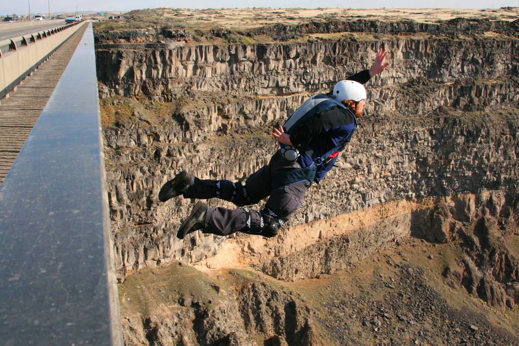
As I am crossing the bridge over the Snake River at Twin Falls, ID I think I really should stop for a picture. At this point the river has formed quite a deep canyon with nearly vertical walls and the citizens of town have built what looks to be a very nice golf course running along the river. Below is one of the Internet images of the Perrine Memorial Bridge at Twin Falls.
Snake River Bridge at Twin Falls, Idaho
I missed the north side overlook and did not want to turn around so kept going through town and was soon on the two lane blacktop heading south to the Nevada border. I talked in an earlier blog posting about the satisfaction I can get from doing something that is a bit dangerous but that I did not
consider myself an adrenaline junkie. This picture on the right came up when I was searching the web for an image of the Twin Falls bridge. I guess some guys do need more of a rush than I require. One of the things I have never done and regret not trying when I was younger was skydiving. I hurt my back as a boy when I was trying to dive off an Olympic Platform at Michigan State University's competition pool and was never comfortable enough with the strength of my spine to actually jump out of an airplane. What bothered me was that I was also scared of heights and often felt I might be using the back as an excuse not to have to face my fears. I was further shammed when my good friend Mike Holmstrom made a tandem jump while we were living in Sydney, Australia. Mike could just not stop talking about how exciting and wonderful the experience was. But to my knowledge he never took another jump.
As i was thinking, I was also keeping an eye out for the village of Rogerson, ID where the cut-off to Jarbidge intersects. If you are heading to the little Nevada town, you turn off and head west for a few miles of pavement which quickly turns to gravel and winds for another 50 miles before you reach your destination and in my case, I will need to keep on going for another 50 miles beyond Jarbidge, before re-gaining the good road surface. I stop at the small Sinclair Oil station in Rogerson to consider the options. I know that there is only one very small place to stay in Jarbidge which has only a handful of rooms so I feel, if I start on this route, I will have to continue all the way on to Elko. That would mean covering the full 100 miles of gravel, more than twice the amount I handled on Day One. However, I really am interested in seeing this section of Nevada which is new to me and which has some history as well. So the decision is not an easy one.
The location's history is as the site of the last stagecoach robbery in the US that resulted in a fatality. Happened in 1916. Hard to accept that even during WWI when Europe was convulsing with mechanized violence, parts of the US were still being serviced via stagecoach. This road also made news more recently when a large storm in 1995 caused flooding in the Jarbidge canyon and washed out sections of the rough gravel road that ran alongside the Jarbidge River. Residents clamored for the damage to be repaired since the only other route out of town was a treacherous and often impassable in winter trail that ran in the opposite direction and ended in Elko, NV. Like most of the US west nearly all the land around the town is owned and managed by the Federal Government through a number of agencies, principally the BLM (Bureau of Land Management) the the US Forest Service and many others, sometimes with conflicting and overlapping jurisdictions. Since the damaged site itself was located in the Humboldt-Toiyobe National Forest it appeared to be a Federal affair. However, at first neither the Federal or State or County government would accept responsibility for the repair. Ultimately Elko County bowed to citizen pressure and agreed to undertake the job. At that point the Federal folks justified their reputation in the West of being both arrogant and ridiculous. The US Forest Service argued that even though they did not have the responsibility to repair the road they also could not allow anyone else to do so either. Frustrated residents took matters into their own hands and undertook to open the road themselves using their own picks and shovels and muscle power. The result was the usual tangled court battle with injunctions and stays by various judges and the entrance of a gaggle of uninvolved but active and well-funded environmental groups. One was the playfully named Great Old Fat Broads for Wilderness. In the end, the road was repaired without a real decision of the underlying responsibility issues. Old Fat Broads
Even though the route would be an interesting ride and I would like to see the Jarbidge townsite as well, I decide to keep this for another day. I am a bit tired and it is just more than I want to take on right now so I continue on the main road to the Nevada town of Wells and the Interstate 80 intersection.
Downtown Wells, Nevada 2008
A pretty average ride although the terrain to Wells is through gently rolling countywide with higher mountains in the distance on several sides. I was riding though Wells in 2008 shortly after a 6.0 earthquake shook the town and destroyed most of the older downtown section. Nothing much else has happened there since. I don't bother to stop this time except to gas up for the last 50 miles to my hotel in Elko. This goes by fairly quickly but the closer I get to Elko there is an increasing amount of light smoke and haze in the air and it is starting to bother my breathing. By the time I am actually in my room, all I am good for is just sitting, watching TV and waiting for morning.
The next morning is a bit better and while the air quality is noisome it is not devastating. This section of Interstate Highway has been covered by me on many occasions and is quite uninteresting. Perhaps because it is so bland, that a place just outside of Imlay, NV is worth mentioning. This place sits right alongside the highway and really illustrates the difference between the American East and West.
Private home, Imlay, Nevada
Most places in the East if your neighbor painted his house in garish colors and decorated it with bizarre and poorly executed statuary, you would have him declared insane and probably run out of the area, if not committed to an asylum. In the West however you would be more likely to work with your others neighbors to turn his place into a tourist attraction. All you have to do is drive enough in the US West and you will see signs for the World's Largest Cow, The Mystery Cavern, Biggest Haunted House, The Giant Sandhill Crane and many, many more. While I find Imlay's Thunder Mountain Park interesting; just not enough so that I feel the need to actually pull off the road. Thunder Mountain
Of much more interest is the roadside installation at the exit for Nightingale, Nevada. This is the the geothermal power plant whose expansion pipes run right alongside the highway. As you would expect there is not a lot of aboveground construction but the constant steam escaping from numerous locations around the plant indicate that it is under operation. After all the discussion about volcanos earlier, this plant stimulates me to begin thinking about geothermal potential in general. There are lots of geologically active areas in the US and with all the bad consequences we had been thinking about concerning Yellowstone and other hot spots it is interesting that those dangers might actually be turned into a energy advantage. I have driven by this plant many times but this time I really give it some thought. I wonder why geothermal is not a bigger part of our energy supply. It seems to me that with today's technology, there should be no reason why we couldn't get almost all our fixed energy needs from harnessing the earth's core heat. But we don't. I guess that it must be more and perhaps much more expensive to do geothermal than fossil fuel power generation. But with all the trouble, blood and treasure we have expended on foreign oil, there would seem to almost no price that we could not pay to fully take advantage of this resource. I thought perhaps it would take more capital than even the big oil guys corporations could comfortably risk but, if so, then the government could play a part like the Tennessee Valley Authority or the Alberta Oil Sands development in Canada. In any case, speculating about geothermal possibilities got me through to Reno. All in all a very successful and enjoyable trip.
I subsequently asked a neuclear chemist friend of mine to guess why geothermal was not more prevalent. He said he thought the engineering challenges of handling not only the very high heat at deptht might be a costly problem but that many substances that are found in those parts of the earth's mantle can be highly corrosive and that adds another level of challenge in terms of unusual or rare and expensive materials that might be required in the plant operation.+++


 d
d


